
DO YOU REMEMBER MY LAST QUESTION IN MY LAST BLOG,
" THE START " ? Well I said those sailors 500 or 600 years ago, how did they cope with these conditions ? And why did they do it, without knowing necessarily what was behind the horizon ? This leads me to the second part of my previous blog "The beginning of the end" , with the new title :
THE "ERDAPFEL"
OR
THE BEGINNING OF A NEW ERA.

Spices : Only Gold was equal in value
Remember:
The Mediterranean and its connected land routes to the East
( loosely called East India ) transported almost 80 % of all trade in the then known world, when the Ottomans started to interrupt this business.
So alternative routes were sought,
specifically for the lucrative spice trade with Asia.
At the end of the 15th century, Britain was locked in skrimishes with the French and Spanish fleets, so their seafarers knew part of the Atlantic, but kept closer to land. The French as well, although they had already conquered into the western parts of Africa, and thereby knew about the Canaries and may be Cape Verde.
But the Portuguese under King John II in those years were actually the most active explorers. They developed the scheme to reach Asia by going East, so around Africa,and
Bartolomeu Dias in 1488 reached Cape of Good Hope, the southern tip of Africa..
The Portuguese had also previously discovered the Azores and Madeira. So they knew the eastern part of the North and South Atlantic well.
And yet it was somebody else, "who added one and one, got three",
and went for it ,
if you know what I mean.
| His name : Christopher Columbus. Born in Genoa in 1451 where his father had a cheese stand in the city. So no sea legs here. Now I don't want to repeat your school lessons, but will try to make you understand why it was him who did it ! And that from a sailor's perspective : |  Genoa from the Nuremberg chronicles (woodcut) around 1493 |
Young Columbus started a business apprenticeship with famous Genoese families . As such he began to travel, most likely by sea I guess, to countries like England, Ireland, possibly Iceland, and in the Med as far as the Aegean Sea.
He also visited frequently his brother Bartholomeo in Lisbon, who had become a cartographer in the meantime.
I am convinced that through these travels he got an understanding of the world at sea, of sailing and sailing routes, and prevailing winds and weather patterns.
Through his brother I assume he also got hold of the most advanced and most likely secretive chart works and records of Portuguese explorers.
According to the historian Edmund Morgan, he also learnt Astronomy, and read besides history some travel books like those of Marco Polo and Sir John Mandeville.
He must also have been visiting the Azores, Madeira, its neighbouring island Porto Santo, and the Canaries.
In 1478 he married the daughter of the previously mentioned Bartolomeu Perestrello, the Governor of Porto Santo.
( Remember my blog " The Island of Wood " ? )
My speculation is that later he also met a German with the name of Martin Behaim , a cosmographer, astronomer and geographer who had married in 1486 the daughter of the Governor of the Azores, a Flemish community leader form Antwerp, and stayed there for some years.
Now you did not hear about this in school, did you ? Because your teacher was not a sailor, simple !
BUT WHY IS THIS IMPORTANT ?
| 1. Well first, what does a German do in the Azores during those years. Martin , who came from Nuremberg, worked in Commerce , and as such ended up in Antwerp, doing a lot of trade with colleagues in Lisbon,Portugal.. When the Portuguese discovered the Azores, the first settlers were persecuted Flemish, who they gave protection to. Through the Antwerp/Lisbon connection and him accompanying Portuguese sailors and explorers along the African coast, Martin ended up in the Azores . Now by coincidence, Martin was also a cartographer. He most likely collected through his travels between the various islands and archipelagos of the Atlantic as much information as known at that time about the world, and as a result created......a terrestrial globe, which is the oldest surviving one . He called it the "Erdapfel" (" Earth-Apple"). No idea whether he had a specific apple type in mind, but the name stuck. The original can still be admired in the Germanic Museum in Nuremberg, but I am happy to report that I have a copy in my study. Looking at it is fun. | 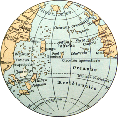 2. "ERDAPFEL" Not only with tiny german words scribbled on it ( here in Latin though ) but no America !!!!! It wasn't discovered yet of course. But a huge " asian" land base starting east of Europe and reaching all the way around this Globe ending somehow in the West from Portugal behind the Atlantic. He produced it in 1492, the year of Columbus's first voyage, and it would not surprise me if Columbus had discussed Behaim's findings with him in the years before and which had influenced his vision on distances and lands to be discovered. May be he had one on board of his ship. I have no proof of this, but who knows ? |
| 3. Anyway. because of this or else , Columbus got it utterly wrong, that is the funny side of the whole Columbus saga . The navigational and geographical mistakes he did were grave ones, because the world during his life time knew already better. And this was part of the reasons why some Courts of Europe and their advisors had given a 'thumb down' on Columbus's plans to sail West to reach "the Indies" . The only thing he got right however was fundamental and is being applied until this very day, this very moment indeed. The whole ARC fleet is following his footsteps. |  4. He discovered, or better he realised there was a pattern emerging of favourable winds and currents around the Atlantic - in a big circle actually. He must have realised that following south of the Canaries, the winds would be North East and further south would turn East. He must have also realised that a possible return of his journey would be on the other side of whatever expected him was to go North, until westerly winds would develop and bring him back to the Azores. |
Now what makes me belief that this happened ?
I have no proof but I had an interesting discussion with Jimmy Cornell, the founder of the ARC rally 26 years ago.
He confirmed that one of Columbus's three ships with the name Santa Clara, or La Nina as her nickname,
had originally a latin sail plan, like those boats in the Mediterranean.
But he changed it to a square rigger, ie sails that are predestined to sail with the wind from behind.
Why should he have done that if he hadn't suspected the essential of Atlantic sailing and its crossing?
Go West with Easterlies in the South and go East with Westerlies in the North.
Am I too smart here or what?
And that, folk, is all for today. I believe it is time for another brake. I don't want you to get bored !
THE STORY WILL THEREFORE CONTINUE IN MY NEXT BLOG
"The beginning of a new era"
 RSS Feed